What makes Chhatrapati Sambhajianagar different
Aurangabad, officially known as Chhatrapati Sambhaji Nagar, also spelt Chhatrapati Sambhajinagar, Chhatrapati Sambhajinagar, is a city in the Indian state of Maharashtra. It is the administrative headquarters of Chhatrapati Sambhajinagar district and is the largest city in the Marathwada region. Located on a hilly upland terrain in the Deccan Traps, Chhatrapati Sambhajinagar is the fifth-most populous urban area in Maharashtra after Mumbai, Pune, Nagpur and Nashik with a population of 1,175,116. The city is known as a major production centre of cotton textile and artistic silk fabrics. Several prominent educational institutions, including Dr. Babasaheb Ambedkar Marathwada University, are located in the city. The city is also a popular tourism hub, with tourist destinations like the Ajanta and Ellora caves lying on its outskirts, both of which have been designated as UNESCO World Heritage Sites since 1983. Other tourist attractions include the Sambhajinagar Caves, Devagiri Fort, Grishneshwar Temple, Jama Mosque, Bibi Ka Maqbara, Himayat Bagh, Panchakki and Salim Ali Lake. Historically, there were 52 Gates in Chhatrapati Sambhajinagar, some of them extant. In 2019, the Aurangabad Industrial City (AURIC) became the first greenfield industrial smart city of India under the country's flagship Smart Cities Mission.
-
History Of Chhatrapati Sambhajianagar.
Khaḍkī was the original name of the village which was made a capital city by Malik Ambar, the Prime Minister of Murtaza Nizam Shah II, Sultan of Ahmednagar. Within a decade, Khaḍkī grew into a populous and imposing city. Malik Ambar died in 1626. He was succeeded by his son Fateh Khan, who changed the name of Khaḍkī to Fatehnagar. With the capture of Devagiri Fort by the imperial troops in 1633, the Nizam Shahi dominions, including Fatehnagar, came under the possession of the Mughals. In 1653, when Mughal prince Aurangzeb was appointed the Viceroy of the Deccan for the second time, he made Fatehnagar his capital and renamed it Aurangabad. Aurangabad is sometimes referred to as Khujista Bunyad by the chroniclers of Aurangzeb's reign.
In 1667 Muazzam, son of Aurangzeb became governor of this province. Before him Mirza Rajah Jai Singh was in-charge of this province for some time.
In 1681, after Aurangzeb's coronation as emperor, he shifted his court from the capital city of Delhi to Aurangabad in order to conduct his military campaigns in the Deccan. The presence of Mughal elites in the city led to urban development, as numerous public and private buildings were constructed. Though Aurangzeb chose not to reside in the city after 1684, the city retained importance as the primary military outpost of the Mughal Deccan, attracting wealth and turning Aurangabad into a centre of trade; the manufacture of embroidered silks emerged during this period and is still practised in Aurangabad today. Mughal Aurangabad was also a cultural hub, serving as an important centre of Persian and Urdu literature. During the Mughal era, Aurangabad had an estimated population of 200,000 people, living in 54 suburbs.
In 1724, Asaf Jah, a Mughal general and Nizam al-Mulk in the Deccan region, decided to secede from the crumbling Mughal Empire, with the intention of founding his own dynasty in the Deccan. Aurangabad continued to be politically and culturally significant for the next 40 years as capital of Asaf Jah's new dominion, until his son and successor Nizam Ali Khan Asaf Jah II transferred the capital to Hyderabad in 1763. The loss of Aurangabad's privileged position led to a period of economic decline; by the beginning of the 19th century, the city had become notably underpopulated, leading to the crippling of its administration, and its buildings were in decay. However, Aurangabad would continue to be important as the "second city" of the Nizam's dominions for the remainder of the polity's lifetime.
In 1816, the British established a cantonment outside Aurangabad (as they did in other parts of the Nizam's dominions), but were discouraged from entering the city proper by the Nizam's officials. As a princely state under British suzerainty, the Nizam's Hyderabad State was quasi-autonomous, meaning that Aurangabad's culture was somewhat free of colonial influence.
Aurangabad began to industrialise in the late 19th century, with the city's first cotton mill being opened in 1889. The population of the city was 30,000 in 1881, growing to 36,000 over the next two decades. Aurangabad was particularly affected by Deccan famines in 1899-1900, 1918, and 1920, causing surges in crime.
Following Indian independence, Hyderabad State was annexed into the Indian Union in 1948, and consequently Aurangabad became a part of the Indian Union's Hyderabad State. In 1956, it passed into the newly formed bilingual Bombay State, and in 1960 it became a part of Maharashtra state.
Bal Thackeray in 1988 proposed the city to be renamed as Sambhajinagar. The local governing body i.e., City Corporation passed a resolution on name change in 1995. On 29 June 2022, the Shiv Sena-led Maharashtra cabinet approved the renaming of Aurangabad to Sambhaji Nagar, after Sambhaji Bhosale, second Chhatrapati of the Maratha Empire. -
Geography of Chhatrapati Sambhajinagar.
The co-ordinates for Aurangabad are N 19° 53' 47" – E 75° 23' 54". The city is surrounded by hills on all directions.
Climate
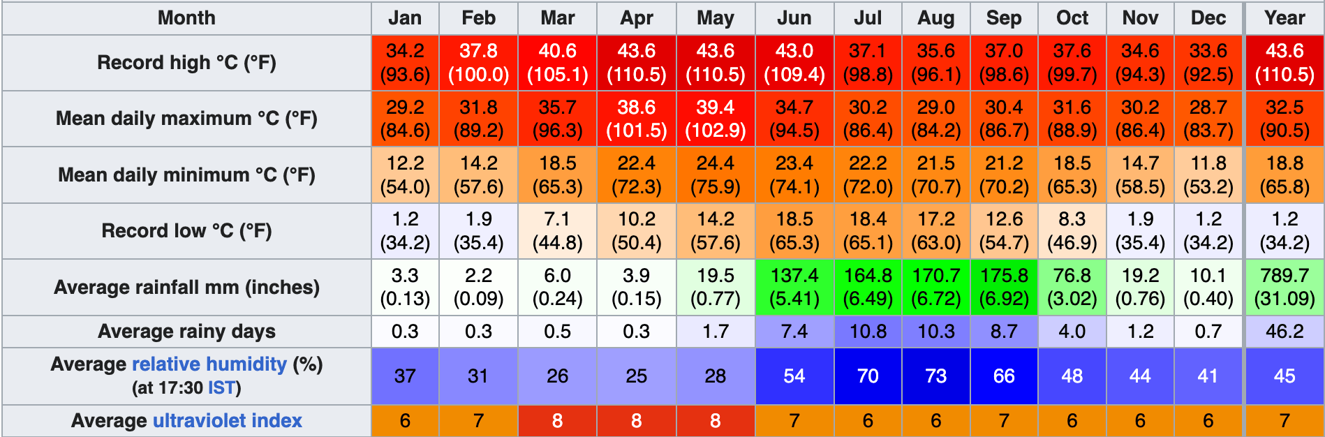
Aurangabad features a semiarid climate under the Köppen climate classification. Annual mean temperatures range from 17 to 33 °C, with the most comfortable time to visit in the winter – October to February. The highest maximum temperature ever recorded was 46 °C (114 °F) on 25 May 1905. The lowest recorded temperature was 2 °C (36 °F) on 2 February 1911. In the cold season, the district is sometimes affected by cold waves in association with the eastward passage of western disturbances across north India, when the minimum temperature may drop down to about 2 °C to 4 °C (35.6 °F to 39.2 °F).
Most of the rainfall occurs in the monsoon season from June to September. Thunderstorms occur between November and April. Average annual rainfall is 710 mm. The city is often cloudy during the monsoon season and the cloud cover may remain together for days. The daily maximum temperature in the city often drops to around 22 °C due to the cloud cover and heavy rains.
Geology
The entire area is covered by the Deccan Traps lava flows of Upper Cretaceous to Lower Eocene age. The lava flows are overlain by thin alluvial deposits along the Kham and Sukhana river. The basaltic lava flows belonging to the Deccan Trap is the only major geological formation occurring in Aurangabad. The lava flows are horizontal and each flow has two distinct units. The upper layers consist of vesiculara and amygdaloidal zeolitic basalt while the bottom layer consists of massive basalt. The lava flows are individually different in their ability to receive as well as hold water in storage and to transmit it. The difference in the productivity of groundwater in various flows arises as a result of their inherent physical properties such as porosity and permeability. The groundwater occurs under water table conditions and is mainly controlled by the extent of its secondary porosity i.e. thickness of weathered rocks and spacing of joints and fractures. The highly weathered vesicular trap and underlying weathered jointed and fractured massive trap constitutes the main water-yielding zones. The soil is mostly formed from igneous rocks and is black, medium black, shallow and calcareous types having different depths and profiles.
-
Demographics of Chhatrapati Sambhajinagar.
According to the 2011 Indian Census, Aurangabad has a population of 1,175,116, of which 609,206 are males and 565,910 are females. Population in the age range of 0 to 6 years is 158,779. The total number of literates in Aurangabad was 889,224, which constituted 75.67% of the population with male literacy of 79.34% and female literacy of 71.72%. The effective literacy rate of 7+ population of Aurangabad was 87.5%, of which male literacy rate was 92.2% and female literacy rate was 82.5%. The Scheduled Castes and Scheduled Tribes population is 229,223 and 15,240 respectively. There were 236659 households in Aurangabad in 2011.
Religion
The majority of the population in Aurangabad are Hindu (51%), followed by 30% Muslim, 15.2% Buddhist and 1.6% Jain. There are a substantial number of adherents of Sikhism and Christianity in the city. Buddhists are of Navayana tradition who are mostly scheduled castes.
Language
Marathi is the official language of the city. Marathi is also the most commonly spoken language in the city, followed by Urdu and Hindi.
-
Administration and politics of Chhatrapati Sambhajinagar
Local administration
Chhatrapati Sambhajinagar Municipal Corporation (CSMC) is the local civic body. It is divided into six zones. The Municipal Council was established in 1936, the Municipal Council area was about 54.5 km2. It was elevated to the status of Municipal Corporation from 8 December 1982, and simultaneously including eighteen peripheral villages, making the total area under its jurisdiction to 138.5 km2 extended its limits.
The city is divided in 115 electoral wards called as Prabhag, and each ward is represented by a Corporator elected by the people from each ward. There are two Committees, General Body and Standing Committee headed by the Mayor and the chairman respectively. CSMC is responsible for providing basic amenities like drinking water, drainage facility, road, street lights, healthcare facilities, primary schools, etc. CSMC collects its revenue from the urban taxes which are imposed on citizens. The administration is headed by the Municipal Commissioner; an IAS Officer, assisted by the other officers of different departments. Chhatrapati Sambhajinagar Metropolitan Region Development Authority (CSMRDA) is being Formed for the Allover Development of the Region.State and central administration
Chhatrapati Sambhajinagar division is one of the six administrative divisions of Maharashtra state in India. Aurangabad divisions almost completely coincides with the Marathwada region of Maharashtra. Chhatrapati Sambhajinagar contributes one seat to the Lok Sabha – Chhatrapati Sambhajinagar (Lok Sabha constituency). In 2019 general election, AIMIM candidate Sayed Imtiyaz Jaleel was elected as a member of parliament from Chhatrapati Sambhajinagar.
Chhatrapati Sambhajinagar also contributes three state assembly seats namely Chhatrapati Sambhajinagar East, Chhatrapati Sambhajinagar Central and Chhatrapati Sambhajinagar West which are represented by Atul Moreshwar Save (BJP), Pradeep Jaiswal (Shiv-Sena) and Sanjay Shirsat (Shiv-Sena) respectively since 2019 Maharashtra Legislation Assembly election. -
Economy of Chhatrapati Sambhajianagar.
Chhatrapati Sambhajinagar is considered to be a classic example of efforts of state government towards balanced industrialisation of state. The city was a major silk and cotton textile production center. A fine blend of silk with locally grown cotton was developed as Himroo textile. Paithani silk saris are also made in Chhatrapati Sambhajinagar. With the opening of the Hyderabad-Godavari Valley Railways in the year 1900 several ginning factories were started. After 1960, Maharashtra Industrial Development Corporation (MIDC) began acquiring land and setting up industrial estates. The Maharashtra Center For Entrepreneurship Development's main office is in Chhatrapati Sambhajinagar. Major industries in Chhatrapati Sambhajinagar are manufacturing, biotechnology, pharmaceuticals and automobiles etc. In the 1990s, land near Shendra village on the Chhatrapati Sambhajinagar-Jalna route was purchased. The MIDC created the Waluj and Chikalthana Industrial Areas as part of its efforts, which were quickly purchased.
Chhatrapati Sambhajinagar is surrounded by the industrial areas (MIDCs) of Chikhalthana, Shendra and Waluj MIDC. A new industrial belt namely Shendra - Bidkin Industrial Park is being developed under DMIC. Major Siemens and automotive companies such as BMW, Audi India, Skoda Auto, Bajaj Auto and Goodyear Tire and Rubber Company have there units in the city. One of the largest Russian Steel Company NLMK has set up plant in DMIC Shendra phase. -
Transport.
Air
Chhatrapati Sambhajinagar Airport is an airport serving the city and has connecting flights to Hyderabad, Delhi, Mumbai, Bangalore, Ahmedabad, Udaipur, Tirupati, Visakhapatnam and Thiruvananthapuram. In 2008, flights were made available to the people travelling to the Hajj pilgrimage.
Rail
Chhatrapati Sambhajinagar railway station is the major railway station under Nanded railway division of the South Central Railway zone. It is located on the Kacheguda-Manmad section and has rail connectivity with major cities such as Delhi, Hyderabad, Latur Road, Manmad, Mumbai, Nagpur, Nanded, Nashik Road, Nizamabad and Pune. The work of DPR preparation is ongoing for metro in Chhatrapati Sambhajinagar from Shendra and Waluj. The work of surveys and DPR is also ongoing for high speed rail line from Mumbai to Nagpur, which will have a halt in Chhatrapati Sambhajinagar.
Road
Central Bus Stand and CIDCO bus stand, Chhatrapati Sambhajinagar of MSRTC are the main public transport centres. Buses are available to every major bus depots of Maharashtra. Ola Cabs service is available in city. Major long route Chhatrapati Sambhajinagar buses reach Delhi, Jaipur, Gandhinagar and Hyderabad in 2–3 days. MSRTC buses are also available for all district of Maharashtra and neighbouring State's cities like Indore, Ujjain, Surat, Vadodara, Khandwa, Burhanpur, Khargone, Bhopal. There are Smart City Bus service in Chhatrapati Sambhajinagar as the part of public transport in Chhatrapati Sambhajinagar Metro City.